


Login to Continue Learning
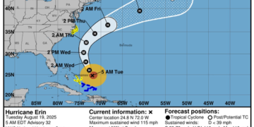
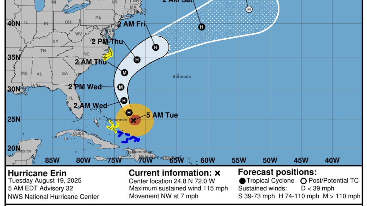
According to a 2 p.m. ET advisory from the National Hurricane Center on August 19, Hurricane Erin is located about 655 miles south-southeast of Cape Hatteras, North Carolina, with maximum sustained winds near 105 mph. The hurricane center forecasts that Erin will continue to strengthen as it moves over the western Atlantic Ocean through the week.
Erin is moving toward the north-northwest and is expected to maintain this motion through Tuesday, followed by a northward movement on Wednesday, and then a northeastward movement on Thursday. The center of Erin is forecast to pass to the east of the Bahamas on Tuesday and then move over the western Atlantic between the U.S. East Coast and Bermuda on Wednesday and Thursday.
Big waves and rough surf are expected along the Atlantic Coast from Central Florida to Canada. Evacuations are underway along at least two islands in North Carolina’s Outer Banks due to an expected storm surge and waves of over 10 feet. Heavy rainfall is also possible, with potential for 1 to 2 inches and a local maximum of 4 inches on the Outer Banks Wednesday night into Thursday.
The National Weather Service advises people to stay out of the ocean to avoid deadly surf conditions through at least Thursday. A storm surge watch is in effect from Cape Lookout to Duck, North Carolina, indicating a possibility of life-threatening inundation due to rising water moving inland from the coastline.
Related Post


In addition to Erin, the hurricane center is tracking two other systems in the Atlantic that could develop into tropical weather. One system located over the central tropical Atlantic may produce a tropical depression by the end of the week or weekend. The second system near Cabo Verde Islands is expected to move westward and has a 30% chance of forming within the next seven days.
For more information, see the National Hurricane Center’s path tracker and spaghetti models.


