


Login to Continue Learning
Summer is transitioning to fall, with forecasters predicting lingering heat, significant cool downs, and hurricane danger. Here’s what you need to know.
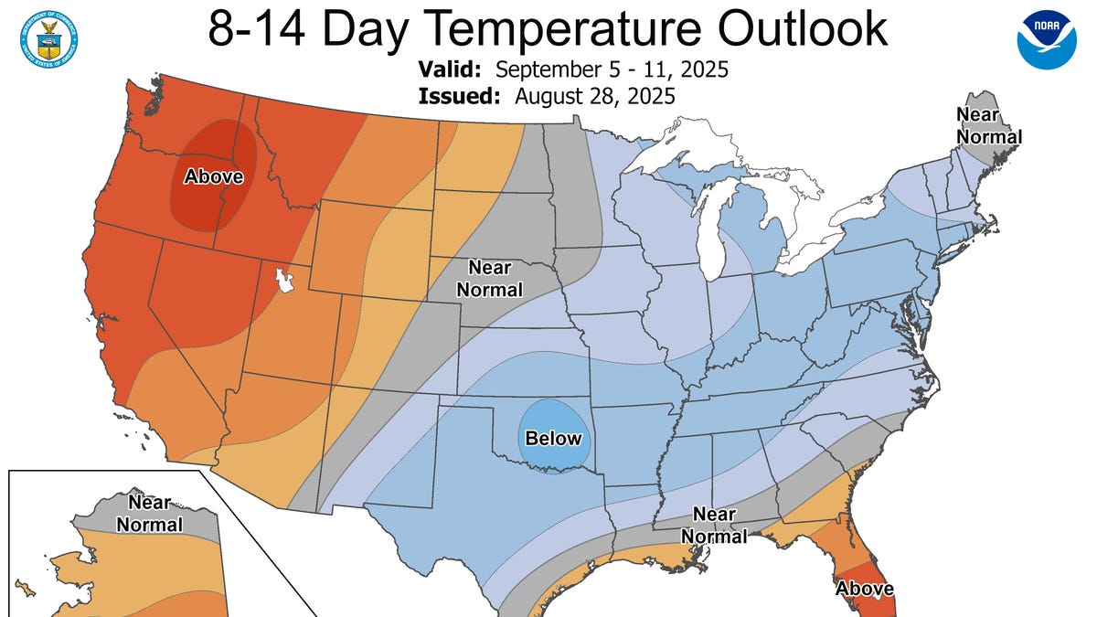
Short-term forecasts indicate that a fresh area of high pressure will move into the Northeast over the weekend and remain in place for Labor Day, bringing comfortable days with good sunshine and chilly nights. Temperatures will be around 15 degrees below historical averages during the day, ranging from the 60s to 70s, and near-record lows at night.
Federal forecasters concur with this prediction, noting that “current outlooks for early September favor below-normal temperatures for much of the Midwest and East,” according to Dan Collins from NOAA’s Climate Prediction Center. Meanwhile, residents in Florida and the western U.S. can expect summerlike warmth to continue through most of September.
By mid-September, however, the warmth should return to the East, as AccuWeather senior meteorologist Chad Merrill predicts above-average temperatures. Nevertheless, extreme summertime heat is unlikely this season; “those temperatures are finished for the year,” Merrill stated.
Related Post


The Northeast has experienced a lack of rainfall, leading to an expansion of drought in New England. Drought conditions will worsen before tropical moisture moves in later in September.
Hurricanes are expected to return as the Atlantic Basin enters its busy period from mid-September into October and even November. The current storm lull during late August and early September is due partly to cool water and dry air, but forecasters predict increased tropical activity by mid-month.
As we approach winter, there’s an increasing chance of La Niña developing, according to Johnna Infanti from NOAA’s Climate Prediction Center. This climate pattern, characterized by cooler-than-average sea-surface temperatures in the Pacific Ocean, could boost hurricane activity in late fall and early winter.
Typically, La Niña winters can bring cooler temperatures to the northern U.S., diminished storm track activity over the southern tier, leading to milder temperatures and below-normal precipitation. The storm track is often shifted northward, bringing above-normal precipitation to parts of the Ohio Valley and Great Lakes.
However, predictions for this event are uncertain, with indications pointing to a short-lived, weak La Niña. Weak and brief events tend to have less reliable impacts than strong, long-lived ones.
Fall 2025 is shaping up to be an interesting season with varied weather conditions. Stay tuned for updates!


