


Login to Continue Learning
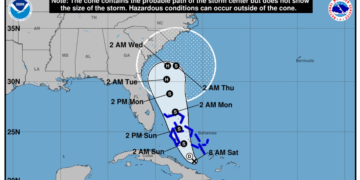
The National Hurricane Center’s forecast tracks two significant tropical systems that could pose a threat to the East Coast. First, Hurricane Humberto is currently a major hurricane in the Atlantic Ocean. Second, another system strengthened into Tropical Depression Nine on September 27 and will likely be named Imelda. This depression is expected to travel parallel to a stretch of coastline from Florida to the Carolinas.
Third, unrelated heavy rainfall is predicted across parts of the southeastern United States. The three weather systems may interact with each other, leading to increased uncertainty in the forecast.
On Saturday, September 27, the forecast calls for heavy rain, dangerous surf, and high-end tropical storm-force winds along the Southeastern U.S. coast by Tuesday, September 30, as Potential Tropical Storm Imelda approaches from the Bahamas and Hurricane Humberto continues its path to the east.
The National Hurricane Center’s official forecast suggests that Imelda could become a hurricane off the Florida coast before briefly slowing near South Carolina. Slow-moving storms are particularly concerning because they can lead to significant rainfall. The center director, Michael Brennan, warns that heavy rainfall could be an additional threat in addition to some of the heavy rainfall already being seen across portions of the southeastern United States this weekend.
Related Post


Greater uncertainty than usual remains in the forecast due to factors like a cold front and upper-level disturbances affecting the region, questions about the speed and timing of both systems, and potential interactions between Humberto and Imelda. Unrelated rain is also contributing to the risk of flooding even before the tropical weather moves in.
The chance for serious flooding is particularly concerning in coastal southeastern parts of North and South Carolina through early October. Between 5 and 10 inches of rain could fall, with higher totals possible locally. The Weather Prediction Center warns that such rainfall can lead to widespread life-threatening flooding, especially if the storm slows down or stalls.
The forecast track for Imelda shows the most likely path of its center but does not illustrate the full width of the storm or its impacts and is unlikely to stay within the cone up to 33% of the time.


