


Login to Continue Learning
Marine protected areas (MPAs) now cover over 8% of the world’s oceans. Yet, these areas can be under constant threat from illegal fishing. Recent high-profile incidents, such as a Chinese fleet near the Galapagos Islands and ships turning off their tracking devices, have raised concerns about undetected poaching.
However, some MPAs are effectively keeping illegal fishing out. A recent global study using satellite technology that tracks large ships even when they turn off their systems found that fully banning industrial fishing in these areas largely prevents poaching.
**What Marine Protected Areas Aim to Save**
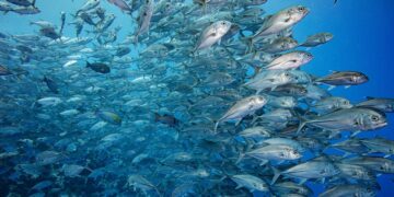
Imagine sea turtles gliding by as striped butterfly fish weave through coral branches. These habitats, where fish and marine life breed and feed, are the treasures MPAs aim to protect.
Related Post


**The Threat of Industrial Fishing**
These vessels can operate worldwide for years at a time, with refrigerated cargo ships ferrying their catch to port. China has a vast global fleet that operates as far away as South America.
Since 1950, the industrial fishing fleet—nearly half a million vessels—has hauled in about 100 million metric tons of seafood annually. Today, over one-third of commercial fish species are overfished.
**Well-Designed MPAs Can Restore Fish Populations**
When well-designed and enforced, MPAs can help restore fish populations and marine habitats. My previous research shows they even benefit nearby fisheries because the fish spill over into surrounding areas.
That’s why expanding MPAs is a cornerstone of international conservation policy. Nearly every country has pledged to protect 30% of the ocean by 2030.
**Big Promises, Big Doubts**
But what “protection” means can vary. Some MPAs ban industrial fishing and are considered the gold standard for conservation. However, most do not meet this standard. Only about 3% of protected areas actually cover industrial fishing bans.
**Shining a Light on the ‘Dark Fleet’**
Much of what we know about global industrial fishing comes from AIS, which ships must use. AI can analyze movement patterns to estimate when and where fishing occurs. But AIS has blind spots—captains can turn it off, tamper with data, or avoid using it entirely.
New satellite technologies, such as synthetic aperture radar (SAR), can detect vessels even when they don’t transmit AIS. It works by sending radar pulses to the ocean surface and measuring what bounces back. Paired with AI, SAR reveals previously invisible activity.
**New Global Analysis Shows What Really Happens**
Two studies published in Science on July 24, 2025, use these satellite datasets to track industrial fishing activity in MPAs.
Our study looked at MPAs where all industrial fishing is explicitly banned. We combined AIS vessel tracking, SAR satellite imagery, official MPA rules, and implementation dates showing when bans took effect. The analysis covers nearly 1,400 marine protected areas spanning about 3 million square miles where industrial fishing is explicitly prohibited.
The results were striking:
– Most of these MPAs showed little to no signs of industrial fishing.
– We detected an average of five fishing vessels per 100,000 square kilometers in these areas, compared to 42 in unprotected coastal areas.
– 96% had less than one day per year of alleged illegal fishing effort.
The second study used the same data to examine a broader set of MPAs—many that allow some fishing. They documented substantial fishing activity, with about eight times more detections than in the protected areas that ban industrial fishing.
Combined, these studies lead to a clear conclusion: Marine protected areas with weak regulations see substantial industrial fishing, but where bans are in place, they’re largely respected.
These technological advances have the potential to reshape marine law enforcement by significantly reducing costs. Agencies can now monitor activity remotely and focus patrols where needed most.
That can also have a deterrent effect. In Costa Rica’s Cocos Island National Park, evidence of illegal fishing decreased after satellite and radar-based vessel tracking was introduced. Similar efforts are strengthening enforcement in the Galapagos Islands and Mexico’s Revillagigedo National Park.
Beyond MPAs, these technologies also support tracking oil slicks and deep-sea mining, making companies more accountable for their use of the ocean.


